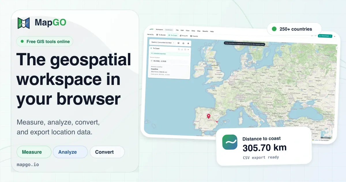
MapGO is a free browser-based geospatial workspace for measuring distances, analyzing coordinates, and converting GIS files.
What is MapGO?
MapGO is a browser-based geospatial workspace that delivers online mapping services and GIS data software capabilities without any local installation. It targets a clear problem: traditional geospatial analysis is often overkill for simple questions like How close is this coordinate to the nearest border? or Which district does this GPS point belong to? These tasks typically require launching a full desktop GIS, loading shapefiles, and navigating a steep learning curve. MapGO removes those barriers by putting an interactive map and a suite of measurement and conversion tools directly in the web browser, accessible from any device with an internet connection.
The product is built by Sebastian Janas and is presented as a "geospatial workspace that runs in your browser" on the main page. The platform is marketed toward professionals who deal with location data every day, including GIS analysts, logistics planners, real estate professionals, environmental researchers, and web developers. Its emphasis on being a lightweight alternative to heavyweight GIS suites is clear from the landing page, which highlights the ability to measure, analyze, and convert location data without downloads or setup. For organizations that have not invested in enterprise GIS infrastructure, MapGO offers an approachable on-ramp. For those that have, it serves as a handy quick-lookup companion that does not require opening a heavier application.
MapGO's positioning is reinforced by its own dataset rather than relying on third-party lookup services. The landing page claims the dataset covers more than 250 countries and territories, with millions of boundary points, including regions, provinces, districts, and sub-regions. This data is the backbone behind every distance-to-border, distance-to-coastline, and location hierarchy query. By controlling this layer internally, MapGO can guarantee consistent response times and accurate results, which is a significant advantage in an industry where data quality varies widely.
In the broader context of geospatial tools, MapGO occupies a niche between free public services like LatLong.net and full-featured GIS platforms. It is far more focused than a general-purpose mapping library, but more flexible than a simple coordinate converter. The trade-off is intentional: MapGO does not attempt to handle raster analysis, 3D terrain, or custom cartography. Instead, it perfects the most common spatial operations that professionals need to perform on a daily basis. To begin, a user simply navigates to the MapGO workspace and starts exploring.
The workspace itself is designed with a dual-pane layout. On the left, a collapsible sidebar lists every available tool, from location hierarchy to file conversion. The central map area is where users drop points and draw polygons. MapGO's interface is clean and readable, and the mockups on the landing page show a dark map with bright accent colors, giving it a modern feel that appeals to developers and analysts alike.
Key Features
MapGO offers a focused set of tools, each of which is accessible directly from the workspace sidebar. Local navigation is straightforward, and the feature set is intentionally narrow to keep the product fast and usable. The following features stand out.
Location Hierarchy Lookup: The location hierarchy tool returns the complete administrative path for any coordinate, from continent down to district. The data is organized into countries, regions, and districts, and the response appears in the workspace alongside a map marker. This is invaluable for geocoding validation, address verification, and data enrichment workflows. For example, a user typing in the coordinates 51.5074, -0.1278 can immediately see London's hierarchy, including the United Kingdom, England, and the Greater London region.
Distance to Border: A dedicated tool computes the straight-line distance to the nearest country or region boundary. Using MapGO's boundary shapefiles, the algorithm finds the closest point on any adjacent border and visualizes it with a line on the map. This feature is especially useful for logistics, security, and real estate use cases where proximity to a national frontier matters. The distance is displayed in kilometers and is updated instantly as the user drags the map marker. The dataset includes both international borders and administrative borders within countries, so the tool can also answer questions like distance to the nearest province line.
Distance to Coast: For coastal proximity queries, MapGO calculates the distance to the nearest point on a coastline, which is derived from high-resolution coastline shapefiles. Real estate portals can use this to generate “distance to beach” metrics, and insurance companies can assess flood risk based on coastline proximity. The result includes a visual indicator on the map, making the output easy to interpret. In the background, MapGO's algorithm selects the closest vertex across millions of coastline points, yet the response time remains near-instant for a single query.
Point-to-Point Distance and Bearing: The measure tool allows two clicks on the map to show the great-circle distance between the points, as well as the bearing in degrees. This is a critical feature for navigation, site selection, and infrastructure planning. The tool also supports drawing polygons for area calculations, circles for radius measurements, and custom shapes for buffer zones. Everything updates live as the user draws, which provides an immediate spatial understanding. This feature is essentially a light CAD tool for geographic coordinates.
GPS Coordinate Converter: The integrated converter transforms coordinates among Decimal Degrees (DD), Degrees Minutes Seconds (DMS), and Degrees Decimal Minutes (DMM). This simple but essential utility eliminates the need for separate online converters and keeps all work within the same workspace. It is particularly helpful for GPS data collected in the field that needs to be standardized for database entry. Users can paste a string like 51°30'26"N 0°07'39"W and get the decimal equivalent in milliseconds.
GIS File Conversion: The file conversion page supports conversions between GeoJSON, KML, GPX, Shapefile, and CSV. Users can upload a file in one format and download it in another, making it easier to move data between web mapping libraries, GPS devices, and desktop GIS software. The interface is straightforward, and the processing happens server-side, so no additional plugins are needed. This is a practical solution for consultants who receive files from clients in varying formats.
Bulk CSV Processing: For users with large datasets, the workspace can process thousands of latitude/longitude rows in a single job. The platform enriches each row with administrative hierarchy, distance to coast, and distance to border, then exports a new CSV with the appended fields. This is a powerful feature for market research, demographic analysis, and risk assessment, since it obviates the need to run individual lookups. The processing is done in batches, so the interface does not freeze, and users can monitor progress.
Developer API: The REST API, available on RapidAPI, offers programmatic access to MapGO's core functions. Endpoints like /full-response-from-coordinates return a structured JSON payload with hierarchy, border distance, and coastline distance. The landing page includes a JavaScript example using fetch, showing how easy it is to integrate. The free tier is generous enough for prototyping and small-scale applications. Developers can sign up on RapidAPI and obtain an API key in minutes.
How It Works
The first step for a new user is to decide whether to test the platform without an account or to sign up for a free account, which raises the daily lookup limit from 5 to 10. After signing up, the user clicks the “Open Workspace” button on the landing page, which loads the interactive map interface. The workspace is a single-page application with a map pane at the center and a toolbar on the side. There is no need to download data or configure projections; the map is preconfigured with sensible defaults.
For a location hierarchy query, the user enters latitude and longitude and presses the lookup button. Within a second, the tool returns the administrative levels from country down to district, displayed in a readable list. The same point can then be passed to the distance-to-coast tool, which calculates and displays the nearest coastline. This chaining of tools is a natural part of the workflow, since the workspace retains the currently selected coordinate across tabs.
For distance measurements, the user selects the measure tool, clicks two points, and the distance appears in a popup. The path is drawn as a line on the map, and the user can adjust the points interactively. Area and radius tools work in a similar fashion, making it easy to delineate a parcel or a buffer zone.
The file conversion workflow is equally simple. From the /convert page, the user clicks the upload area, selects a file, chooses the output format, and starts the conversion. The resulting file is downloaded to the local machine. For bulk CSV, the user drags a CSV with latitude and longitude columns, clicks the process button, and, after a brief processing time, receives an enriched file. The system appends columns like country, region, district, distance_to_coast, and distance_to_border.
For developers, the API workflow happens outside the map interface. The developer subscribes to the MapGO API on RapidAPI, gets an API key, and reads the documentation. The sample code on the landing page shows a simple fetch request to /full-response-from-coordinates with source_latitude and source_longitude parameters. The API returns JSON that can be parsed and displayed in a custom application. The API is RESTful, and the response structure is consistent, which reduces integration effort.
Use Cases
Logistics and Border Operations: A cross-border freight company needs to know the exact distance from each delivery point to the nearest national border. The logistics team uploads a CSV of hundreds of delivery coordinates, and MapGO's bulk processing enriches each record with border distance data. This helps planners estimate customs delays and choose routes that minimize border crossings. The company can then build a dashboard from the resulting CSV.
Real Estate and Site Selection: A commercial real estate broker is evaluating a plot of land for a new seaside resort. By entering the coordinates into the location hierarchy and distance-to-coast tools, the broker gets not only the administrative district but also the precise distance to the shoreline. This objective data becomes a selling point in the property listing and supports feasibility studies. The broker can even draw a buffer around the property to show the nearby coastal area.
Environmental Monitoring and Conservation: Researchers at an NGO track wildlife in a coastal region. They have GPS points for animal sightings and need to understand how many are within a protected coastal zone. After uploading the CSV to MapGO and drawing a buffer around the coastline, the team can filter the data and map the points, creating a simple spatial analysis without requiring a GIS specialist. The workflow saves hours of manual processing.
Web and Mobile App Development: A startup building a travel app wants to display the region and nearest border or coast for each user's current location. Rather than building and maintaining a geospatial database, the developer integrates MapGO's API. The free tier allows the startup to prototype during the early stage, then scale up as user counts grow. The API documentation includes a JavaScript example, which speeds up the initial integration.
Urban Planning and Emergency Response: A city planner needs to quickly locate all public facilities in a certain district. Using the location hierarchy tool, the planner can filter points by district and cross-reference with other datasets. During an emergency, response teams can use the distance-to-border tool to anticipate if a disaster zone is near a national boundary. This quick access to spatial context can inform resource allocation.
Pricing & Value
MapGO uses a freemium model, as indicated by the prominent “Free tier available — no credit card required” note on the landing page. The free tier allows 5 lookups per day for anonymous users, which increases to 10 lookups per day for accounts with a free registration. The platform's pricing page, linked in the main navigation, likely details paid tiers, but the home page intentionally does not disclose exact prices. It does mention that a free account is sufficient for many occasional queries, and the free tier is a smart way for new users to evaluate the product's accuracy.
For heavy users, the paid plans presumably scale with lookup volume, API requests, or batch processing quotas. Given that MapGO bundles a proprietary dataset of boundaries and coastlines, the value proposition is comparable to purchasing similar datasets from proprietary vendors or spending hours curating open-source alternatives. The ability to convert files and run bulk enrichments without errors saves time, which can justify a modest subscription fee. There is also a “Pricing” link in the navigation, so prospective customers can check out their pricing for specifics. For teams that only need a handful of lookups per day, the free tier may be all that is required, making MapGO an accessible tool for small businesses and individual professionals.
The pricing structure is not transparent from the landing page alone. However, given the free tier is generous for occasional use, and the platform is positioned as a lightweight alternative, it is likely that paid plans are affordably priced. The developer API is monetized separately through RapidAPI, which often allows pay-as-you-go or subscription models.
Frequently Asked Questions
Is MapGO really free to start using? Yes, MapGO offers a free tier that gives 5 lookups per day without any account. Creating a free account raises the limit to 10 lookups per day, and no credit card is required. This is ideal for evaluating the tool or for very light usage.
Which coordinate formats does the GPS converter support? The GPS converter handles Decimal Degrees (DD), Degrees Minutes Seconds (DMS), and Degrees Decimal Minutes (DMM). Users can switch between these formats to match the requirements of their specific GPS device or database.
Can MapGO convert geographic data between different file types? Yes, the platform supports conversion among GeoJSON, KML, GPX, Shapefile, and CSV. Users can upload a file in any of these formats and download a converted version, which streamlines data exchange with clients and partners.
What is the developer API, and how do I access it? The developer API is a REST API hosted on RapidAPI. It provides endpoints for location hierarchy, distance to border, distance to coast, and coordinate conversion. Developers can subscribe on RapidAPI, generate an API key, and call the endpoints directly from applications.
Does MapGO have an advantage over using a simple Google Maps query? MapGO provides structured, reliable data for administrative hierarchies and distance-to-border calculations that are not readily available from consumer mapping services. Its bulk processing and API access are also aimed at professionals who need reproducible results.
Can MapGO be used offline? No, MapGO is a cloud-based tool that requires an internet connection for all functionality, including the map rendering and the backend data queries.
Final Verdict
MapGO delivers on its promise of a geospatial workspace that is easy to use and runs entirely in the browser. The most compelling strengths are its clean interface, the proprietary dataset, and the generous free tier. It is a perfect companion for professionals who find it overkill to fire up a full GIS suite for a simple distance or hierarchy lookup. The bulk CSV processing and API access elevate it beyond a toy, making it genuinely useful for small to medium data operations. However, the platform is not designed to replace enterprise GIS. There are no advanced geoprocessing tools, no raster support, and no custom map styling. The free tier's low daily quota may also be a bottleneck for users who want to process large datasets without paying. Nevertheless, for the specific tasks it targets, MapGO is polished, fast, and reliable. It is an excellent choice for developers, analysts, and decision-makers who want geospatial answers without the GIS diploma.
Pros & Cons
Pros
- The entire geospatial workspace operates in the browser, eliminating the need for any software installation.
- MapGO provides 5 free lookups per day without an account and 10 per day with a free account, making it easy to test.
- The built-in dataset covers more than 250 countries and territories with millions of boundary points, enabling accurate distance-to-border and distance-to-coast calculations.
- A dedicated file conversion tool supports GeoJSON, KML, GPX, Shapefile, and CSV, addressing common interoperability needs for GIS users.
- The REST API on RapidAPI allows developers to integrate location hierarchy and distance calculations into custom applications with a free tier.
Cons
- The free daily lookup limits may be insufficient for users who need to process thousands of coordinates on a regular basis.
- The platform does not appear to offer advanced geospatial analysis features such as raster manipulation, spatial statistics, or custom map styling.
- Pricing for paid tiers is not clearly disclosed on the home page, requiring users to visit the pricing page to understand long-term costs.